
By Lynda-Uta Okon | Nigeria’s 2026 wet season has made coastal resilience an immediate policy priority. Flooding and rain-triggered landslides have damaged homes, businesses and infrastructure and displaced households in Calabar, Lagos, Akwa Ibom and parts of Rivers State.
These incidents expose a recurring weakness: emergency response is not consistently linked to the planning, maintenance and household support needed to reduce the next disaster’s impact.[1]
Beyond Nigeria, the catastrophic floods that struck northern Nepal in late August claimed more than a thousand lives. The lesson is urgency, not equivalence: water-related hazards can rapidly result into failures of housing, transport, health systems and livelihoods, and Nigeria needs to act before recurring seasonal emergencies harden into structural losses.[2],[3]
Nigeria has a coastal challenge, which is often treated as a seasonal flooding problem. But it is much bigger than that. The water may arrive during the rainy season, but the damage is produced by a much larger system: rising seas, sinking land in parts of Lagos, intense rainfall, blocked drainages, eroding shorelines, polluted waterways, shrinking wetlands, weak building control, and households that have little capacity to absorb repeated losses.
That distinction changes the policy response. A government focused mainly on flooding will prioritise evacuation, relief, drain clearance and protective structures. A government treating coastal risk as a development challenge will also ask whether people can keep their jobs, whether farms and fisheries can recover, whether schools and clinics remain open, and whether displaced households can secure safe housing and essential services.
Climate change is already a development issue for Nigeria, not a distant environmental concern. The coastal belt—stretching from the South West to the South South—makes that argument especially concrete. Nigeria’s nine coastal states (Akwa Ibom, Bayelsa, Cross River, Delta, Edo, Lagos, Ogun, Ondo and Rivers) contain major cities, ports, oil and gas infrastructure, farms, fisheries, mangrove forests, tourism assets and some of the country’s most densely settled communities. When coastal risk is poorly managed, the cost is felt far beyond the shoreline.[4]
Coastal communities are disproportionately exposed because several hazards overlap in the same places: intense rainfall and river flooding interact with tidal influence, low elevation, shoreline erosion, wetland loss, drainage constraints and, in parts of Lagos, land subsidence. Their exposure is also economic, because fishing, farming, ports, waterfront trade and many informal settlements tie livelihoods and assets directly to water-sensitive environments. Flooding is therefore one visible expression of a broader coastal resilience problem that also includes erosion, ecosystem decline, pollution, displacement, public-health risk and repeated livelihood loss.
The evidence from recent flood assessments, household surveys and climate studies points to a simple conclusion: Nigeria does not mainly suffer from a shortage of climate plans but much more from a shortage of connected implementation. Data sits in different agencies. Drainage, land-use control, environmental protection, emergency management and social protection are managed through different budgets. Warnings are issued, but many households do not receive them or do not have a safe place to go. Relief may arrive after a disaster, but livelihood recovery is often left to affected families.
The policy task therefore is to move from seasonal response to a permanent coastal resilience system.
The scale and limits of the flood evidence
The International Organisation for Migration’s (IOM) joint assessment of 18 states, conducted between 28 October and 8 November 2024, recorded 2,991,406 people affected by floods, including 896,268 displaced people. These figures describe the assessed locations, not a complete national census of flood impacts.[5]
Five states in the WACA coastal-zone grouping—Bayelsa, Cross River, Delta, Edo and Rivers—accounted for 1,061,748 affected people, or 35.5% of the 18-state total. These five states also accounted for 245,821 displaced people, or 27.4% of recorded displacement. The comparison shows a substantial burden, but it does not establish that coastal populations face a higher per-person risk: the assessment was not designed to make that comparison.
Table 1 Flood impacts in the 18 states assessed by IOM in 2024
|
State grouping |
Affected people |
Share of affected |
Displaced people |
Share of displaced |
|
Five coastal-zone states |
1,061,748 |
35.5% |
245,821 |
27.4% |
|
Other 13 assessed states |
1,929,658 |
64.5% |
650,447 |
72.6% |
|
Total |
2,991,406 |
100% |
896,268 |
100% |
Source: IOM DTM, Joint Post-Flood Situation Report — 18 States (30 November 2024); author’s grouping and calculations. Coastal-zone states: Bayelsa, Cross River, Delta, Edo and Rivers. Other states: Adamawa, Anambra, Ebonyi, Enugu, Imo, Jigawa, Kebbi, Kogi, Kwara, Nasarawa, Niger, Oyo and Taraba. The grouping follows WACA, not a direct-shoreline test.
Separate December assessments add Lagos and Akwa Ibom to the picture. Figure 1 shows affected populations in seven selected coastal-zone states. The figures cover different assessment periods and locations; they are not a permanent ranking of vulnerability or a measure of coastal flooding alone.
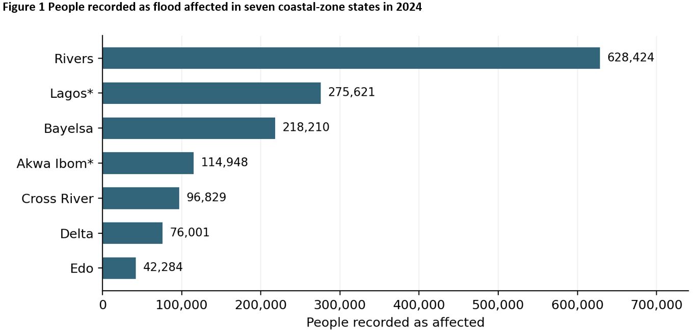
Sources: IOM DTM state assessments and the 18-state assessment. *Lagos and Akwa Ibom were assessed separately in December; the other five states were assessed in late October–early November. Affected people include displaced and non-displaced people. Coverage varies by state.[6]
Lagos illustrates why displacement alone is an inadequate measure of flood damage. IOM recorded 275,621 affected people across 14 local government areas (LGAs), including 2,313 displaced people. Many residents remained in their communities despite damage and disruption. Low recorded displacement should therefore not be read as evidence of low economic or household losses.[7]
These operational counts establish the scale and uneven distribution of recorded impacts. They do not isolate the contribution of sea-level rise, explain every difference between states or measure exposure relative to population. A coastal resilience strategy needs this event evidence alongside information on livelihoods, infrastructure, ecosystems and the causes of local flooding.
Household losses extend well beyond displacement
A survey by the National Bureau of Statistics (NBS), the National Emergency Management Agency (NEMA) and the United Nations Development Programme (UNDP) interviewed 3,600 households in Anambra, Bayelsa, Delta, Jigawa, Kogi and Nasarawa states between April and May 2023 about the 2022 floods. Its findings are not national prevalence estimates; individual indicators also have different eligible respondent groups.[8]
The report found that 64% of households were affected by flooding, 40.9% were displaced and 49.3% had their main food source affected. It also reported 84.9% unable to eat healthy, nutritious food, 69.2% running out of food and 60% hungry with nothing to eat during the flood period. Estimated damage to affected homes averaged about ₦1.97 million at the prices used in the survey. Only 44.8% reported recovery by the interview date.
The response indicators were equally troubling: 19.7% reported government alerts before flooding; 8.3% could evacuate beforehand; 10.4% received support during the floods; and 1.5% reported government assistance afterwards. Support during flooding and government assistance afterwards are separate indicators and should not be conflated.
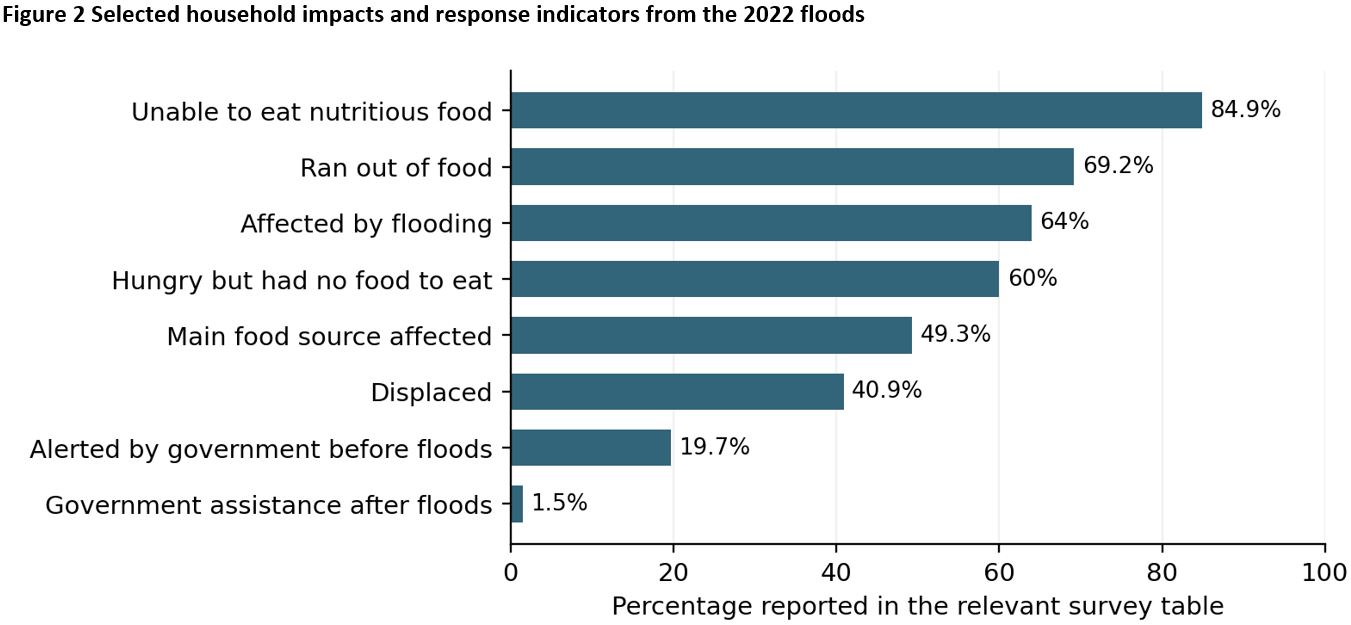
Source: NBS/NEMA/UNDP (2023), survey of 3,600 households in six states. Fieldwork took place in April–May 2023. Percentages are as reported in the relevant tables; eligible respondent groups differ. These are not national prevalence estimates.
This is the gap between warning and action. Better forecasts cannot protect households that do not receive the message, lack transport, cannot find accessible shelter or fear losing the property they leave behind. Effective preparedness must address these practical barriers, including the needs of older people and people with disabilities.
Plan for climate mobility before it becomes an emergency
The World Bank’s 2021 Groundswell study estimates an average of 8.3 million internal climate migrants in Nigeria by 2050 under its pessimistic reference scenario, compared with 1.1 million under its optimistic scenario. The corresponding model ranges are 7.3–9.4 million and 0.4–1.8 million. These outcomes depend on both global emissions and development pathways; Nigerian policy alone cannot determine them.[9]
A separate, finer-resolution coastal analysis projects net climate out-migration of about 0.83 million people from the five-kilometre coastal belt under the pessimistic scenario, with a range of roughly 0.7–1.0 million by 2050. Because the spatial methods differ, this estimate should not be treated as a directly comparable component of the national total.
These are planning scenarios, not predictions of a single mass exodus. Repeated losses can influence decisions to move: declining farm yields, a shop that cannot reopen after another flood, an unreliable road or unaffordable housing after displacement. Nigeria should protect viable communities and livelihoods while preparing for movement that cannot, or should not, be prevented.
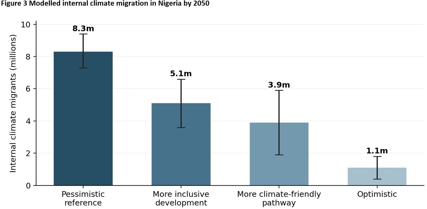
Source: World Bank (2021), Groundswell Africa — Nigeria, Table 3.1. Bars show scenario averages; whiskers show the reported minimum and maximum model results. These are modelled scenarios, not observed counts or forecasts. Lower-emissions pathways depend on global action.
Housing and economic plans should identify safer land and likely receiving areas, protect tenants and low-income households, and link relocation to jobs, schools, health care, transport and secure tenure. Planning must also support people who lack the resources to move.
One coastline requires locally tailored responses
A 2024 satellite study estimated coastal sea-level rise in the Gulf of Guinea at about 3.89 millimetres a year over 1993–2021, with evidence of acceleration. This is a regional finding, not a uniform rate for every Nigerian shoreline.[10]
In Lagos, radar observations from 2018–2021 identified subsidence exceeding 4 millimetres a year across much of the study area. Where the sea rises and the land sinks, relative sea-level rise increases exposure. A coastal wall alone cannot address that combination of pressures, particularly where intense rainfall, blocked drainage and unsafe development also contribute to flooding.[11]
Lagos therefore needs a metropolitan approach combining drainage, water retention, wetland protection, building safety, land-use control and subsidence monitoring. NEMA’s July 2026 assessment in Surulere identified intense rainfall, blocked channels and inadequate drainage maintenance as contributors to flooded homes, damaged property and disrupted livelihoods. The practical task is to combine engineered and nature-based measures around local flood pathways and fund their upkeep.[12]
The Niger Delta presents a different mix of risks. Mangroves and wetlands support fisheries, store water, stabilise shorelines and buffer communities. A 2025 study estimated a 26.4% decline in mangrove cover from the late 1980s to 2023 and identified oil pollution, urban expansion and wave-driven erosion among the pressures. Restoration requires more than planting seedlings: tidal flows, pollution control, community access and long-term maintenance also matter.[13]
The western and central delta need river and tidal flood management alongside ecosystem restoration, resilient jetties and roads, market access, housing repair and support for farming and fisheries. Restoration that ignores livelihoods will struggle to win local support; livelihood programmes that ignore ecosystem decline will remain fragile.
Cross River deserves a distinct approach within the national framework. Its estuaries combine mangrove and fisheries dependence with farming, flood exposure and expanding settlements. IOM recorded 96,829 affected people in its late-2024 assessment, with crop farming among the main income sources in 67% of assessed locations. That percentage refers to locations, not households.[14]
The July 2026 joint assessment in Calabar documented displaced households and damaged buildings in Ekorinim 2 and the Federal Housing Estate, as well as a fatal landslide at Boro Pit. A separate August report identified 24 displaced staff families at the University of Cross River State. These incidents underline the need to link drainage, slope stability, housing safety, sanitation and household recovery.[15]
Cross River could serve as a demonstration area for estuary monitoring, fisheries protection, mangrove restoration, rural access, water and sanitation, and better control of settlement expansion. Comparable indicators should cover all nine coastal-zone states so that priorities are determined by evidence rather than the visibility of individual cities.
Elsewhere, state figures reported in August 2026 put the Akwa Ibom flood burden at more than 36,000 people in 8,169 households across 16 LGAs. In Rivers, NEMA activated temporary shelters after flooding in Oyigbo and Eleme. A late-July NIHSA advisory identified 246 Bayelsa communities at risk; that was a warning, not a count of inundated communities. These reports use different units, periods and coverage and should not be added into a single coastal total.[16]
Seven actions for a national coastal resilience strategy
Nigeria already has climate commitments, meteorological and hydrological agencies, emergency-management institutions and channels for accessing climate and development finance. The priority is to organise delivery around a small number of measurable actions, with clear responsibility for implementation and maintenance. The following actions are thus recommended:
1. Build a shared coastal risk observatory
The Federal Ministry of Environment should work with the Federal Ministry of Water Resources and Sanitation, the Nigerian Meteorological Agency (NiMet), the Nigeria Hydrological Services Agency (NIHSA), the National Council on Climate Change, coastal states and universities to make existing data usable across agencies. A common system should track rainfall, water levels, shoreline change, subsidence, drainage condition, ecosystem health, exposed people and facilities, livelihood losses, displacement and adaptation spending. An annual coastal risk and resilience account should inform state and local budgets. This should be a shared information function with agreed custodians and publication standards, rather than a new bureaucracy.
2. Connect drainage and retention to wider flood protection
State and local authorities should manage drains, retention ponds, pumps, outfalls, wetlands and coastal protection structures as parts of an integrated system. Project selection should follow local flood pathways, risk assessments and long-term maintenance needs. Every major project should have a responsible operator, an asset register, a funded maintenance plan and public performance indicators. Designs should also assess whether protection in one location could worsen flooding or erosion elsewhere.
3. Treat mangroves and wetlands as protective infrastructure
State environmental agencies and their partners should finance restoration and maintenance with the same discipline applied to drainage and roads. Success should be measured by restored tidal flows, seedling survival, reduced pollution, shoreline stability and benefits to fisheries and household incomes, not just hectares planted. Where oil pollution drives ecosystem loss, restoration and pollution control must be planned together, with affected communities involved in design and monitoring.
4. Turn forecasts into local action before flooding occurs
State emergency agencies and local authorities should translate NiMet and NIHSA forecasts into neighbourhood-level warnings with clear evacuation triggers. Before each wet season, they should test communication chains, inspect shelters and routes, identify households needing assistance and pre-position essential supplies. Community groups, market associations, transport unions, schools, clinics, women’s groups and fishing associations should help deliver and test the warnings. Performance should be judged by whether people can act safely, not simply by whether an advisory was issued.
The advisory for 27 August–9 September 2026 illustrates the challenge. It identified 915 communities as facing critical flood risk, including communities in coastal-zone states. A warning on that scale requires practical action in each named community: checking drains and culverts, preparing shelters, communicating evacuation triggers and helping households that cannot move unaided.[17]
5. Make livelihood recovery part of disaster finance
Emergency-management, social-protection and livelihood agencies should coordinate support beyond food parcels and temporary shelter. Households also lose crops, fishing equipment, stock, tools, premises and working capital. Faster arrangements are needed for cash before anticipated shocks, agricultural inputs, fisheries support, small-business recovery and home repair. Insurance may complement these measures where it is affordable and suitable. Social registries should be linked to exposure information with privacy safeguards and a route for eligible households missing from the registers. The objective is to prevent a flood from becoming a prolonged debt and poverty trap.
6. Include climate mobility in housing and economic planning
Planning and housing authorities should identify likely receiving areas and assess safe land, rental pressures, school and clinic capacity, transport and jobs. Planned relocation should be a last resort, with meaningful participation, secure tenure, compensation, livelihood restoration and accessible grievance mechanisms. Support should extend to receiving communities and to people who cannot afford to leave exposed areas.
7. Finance delivery through agreements with coastal states
Federal and state governments should agree costed implementation programmes that link financing to credible baselines, clear responsibilities, maintenance arrangements, safeguards and independently verified results. National standards can be common while the mix of drainage, ecosystem, livelihood and planning measures varies by state. Co-financing requirements should reflect fiscal capacity, with preparation support for states that lack it, so that the most vulnerable places are not excluded because they are least able to develop projects. Coastal resilience should be financed as a programme for jobs, food security, health and urban productivity.
Make resilience a permanent development function
The 2026 wet season has already supplied the warning. The question is no longer whether coastal states will experience repeated water-related disruption, but whether each episode will continue to be treated as a stand-alone seasonal emergency. The policy test is whether incident data, forecasts, drainage and land-use management, ecosystem protection, public health and household recovery can be joined before the next high-risk window becomes the next disaster.
The country’s coastal risks cannot be managed by waiting for the next flood and improving relief alone. Rising seas, subsiding land, intense rainfall, poor drainage, ecosystem loss, pollution and weak development control interact in different ways across the coastal zone. Their consequences include lost income, food insecurity, interrupted schooling and health care, displacement and pressure on receiving communities.
Nigeria should assess which places can be protected, restore natural buffers, help households recover and plan relocation where remaining is no longer viable. Success will depend on shared information that shapes budgets, maintained infrastructure, recovering ecosystems, effective warnings and restored livelihoods. Connecting these functions would make coastal resilience a permanent part of development policy and reduce the human and economic costs of recurring emergencies.
Dr Lynda-Uta Okon, a fellow of the first cohort of the Agora Policy Writing Fellowship, is a Senior Research Fellow at the Institute of Oceanography, University of Calabar.
[1] Cross River State Government (19 July 2026), NEMA and CR-SEMA joint flood and landslide assessment in Calabar. NEMA (14 July 2026), Flood impact assessment in Surulere communities. Daily Times (19 August 2026), LDS Church Donates Relief Items to 1,500 Households in Akwa Ibom. The flood-impact figures are attributed to the state government and SEMA. BusinessDay (27 July 2026), NEMA opens temporary shelter for flood victims in Rivers.
[2]National Flood Early Warning Systems Centre (2026), flood risk advisory for 27 August–9 September (915 communities); TheCable (29 August 2026), https://www.thecable.ng/icymi-fg-says-915-communities-face-critical-flood-risk-over-next-two-weeks/. .
[3]United Nations in Nepal (4 September 2026), “Nepal floods: UN and partners launch $49.6 million emergency appeal,” https://nepal.un.org/en/322156-nepal-floods-un-and-partners-launch-496-million-emergency-appeal. .
[4]West Africa Coastal Areas Management Program / World Bank (2016), “Briefing Note — Nigeria,” https://www.wacaprogram.org/knowledge/briefing-note-nigeria-west-africa-coastal-areas-management-program-waca.
[5] IOM DTM (30 November 2024), Joint Post-Flood Situation Report — 18 States. Field assessments: 28 October–8 November 2024. Coastal-zone grouping and shares are the author’s calculations using WACA’s definition.
[6] IOM DTM (30 December 2024), Joint Post-Flood Situation Report — Lagos State. Field assessments: 1–6 December 2024. IOM DTM (31 December 2024), Joint Post-Flood Situation Report — Akwa Ibom State. Field assessments: 1–6 December 2024.
[7] IOM DTM (30 December 2024), Joint Post-Flood Situation Report — Lagos State. Field assessments: 1–6 December 2024.
[8] NBS, NEMA and UNDP (2023), Nigeria Flood Impact, Recovery and Mitigation Assessment Report 2022–2023. See survey implementation summary and Tables 7, 29–30, 45–46, 49–50, 52, 54 and 62. Fieldwork: 29 April–20 May 2023. Indicators have different eligible respondent groups and should not be treated as national prevalence rates.
[9] World Bank (2021), Groundswell Africa — A Deep Dive into Internal Climate Migration in Nigeria. Table 3.1 and section 3.5.1. National figures are scenario means; ranges reflect model runs. The coastal analysis uses a finer spatial resolution and is not directly comparable with the national totals.
[10] Kemgang Ghomsi et al. (2024), Sea level variability in Gulf of Guinea from satellite altimetry. Scientific Reports 14, 4759. Study period: 1993–2021.
[11] Ohenhen and Shirzaei (2022), Land Subsidence Hazard and Building Collapse Risk in the Coastal City of Lagos, West Africa. Earth’s Future. Radar observations: 2018–2021.
[12] NEMA (14 July 2026), Flood impact assessment in Surulere communities.
[13] Wang et al. (2025), The serious loss of mangrove forest over the largest delta of Africa, Niger Delta: causes and reasons. Marine Environmental Research 210, 107350. The abstract and conclusion describe 1988–2023, while a results passage uses 1986 as the baseline; the memo therefore says “the late 1980s to 2023”.
[14] IOM DTM (10 December 2024), Joint Post-Flood Situation Report — Cross River State. Field assessments: 28 October–8 November 2024. Livelihood percentages refer to assessed locations, not households.
[15] Cross River State Government (19 July 2026), NEMA and CR-SEMA joint flood and landslide assessment in Calabar. Cross River State Government (26 August 2026), UNICROSS appeal for flood-affected staff. The report cites an appeal dated 12 August 2026.
[16] Daily Times (19 August 2026), LDS Church Donates Relief Items to 1,500 Households in Akwa Ibom. The flood-impact figures are attributed to the state government and SEMA. BusinessDay (27 July 2026), NEMA opens temporary shelter for flood victims in Rivers. The Nation (31 July 2026), NIHSA flood-risk advisory for Bayelsa. The count is 246 communities, not LGAs; the warning covered 30 July–5 August 2026 and does not establish that those communities were flooded.
[17] TheCable (29 August 2026), FG says 915 communities face critical flood risk. Advisory period: 27 August–9 September 2026. The article’s opening includes the FCT, but its detailed list places the FCT in the moderate-risk category; the memo avoids that inconsistent attribution.